

Locations of School Streets
Find out which schools in our borough are taking part in the School Streets scheme.
This page has the area, working hours and names of roads where each School Street operates.
So far, we have created 37 School Streets and 5 environmental improvement schemes at schools on main roads.
Suspension of School Streets for Highbury Quadrant and St Jude and St Pauls' Primary Schools
We suspended the School Streets for Highbury Quadrant and St Jude and St Paul's Primary School on 21 July 2025. This is because of the council’s decision to close the schools.
Vehicles can drive these streets at any time.
The council will decide to continue, change or end the School Streets at some time in the future. We will tell you about how you can share your thoughts and views when we have planned to hold a consultation with you about this School Street.
New School Street for Elizabeth Garrett Anderson School and The Gower School
Street name
Donegal Street, Rodney Street, Collier Street and Cynthia Street.
Type of closure
A temporary road closure from September 2026.
Location
- The whole of Donegal Street, from Rodney Street to Penton Street
- The whole of Rodney Street, from Wynford Street to Pentonville Road
- Collier Street, from Cumming Street to Rodney Street
- The whole of Cynthia Street
Road closure times
- During term time
- 8:15am to 9am
- 3pm to 4:30pm
- Monday to Friday
Why we have proposed this change
We installed the School Street under an 18-month experimental traffic order. We are monitoring the street to find out the impact it will have on the local area.
This is a trial for 18 months. When the experimental traffic order begins, there is an "objection period" for 6 months.
How to comment on this change
If you want to make an official objection, saying "no" to this change, you have write to us and explain why you are objecting.
You can send an objection until 2 March 2027.
Send it to us
- by email: environment@islington.gov.uk
- by post: Environment, 1 Cottage Road, London, N7 8TP
We may publish any objection in a public document or on a webpage.
Ambler primary school
Street name
Romilly Road
Type of closure
A temporary road closure will be introduced
Location
Romilly Road (between Monsell Road and Ambler Road)
Road closure times
- From 25 March 2019
- 8:30am to 9:15am and 3:15pm to 4pm during term time
- Monday to Friday
Why we have proposed these changes
In November 2018 we consulted local residents, businesses and the Ambler Primary School community on restricting traffic on Romilly Road, between Ambler Road and Monsell Road, at school start and finish times. The results of the consultation showed that 82% of respondents supported the scheme.
Many of Islington’s schools are located in or near areas of high pollution and children are particularly vulnerable to the effects of air pollution. The School Street Scheme aims to reduce through traffic which will make a safer and more pleasant environment for everyone.
For more information on school streets contact publicrealm@islington.gov.uk.
Ashmount primary school
Street name
Hornsey Rise Gardens
Type of closure
A temporary road closure will be introduced
Location
The length of Hornsey Rise Gardens
Road closure times
- From 25 March 2019
- 8.30am to 9.15am and 3.15pm to 4pm during term-time
- Monday to Friday
Why we have proposed these changes
In November 2018 we consulted local residents, businesses and the Ashmount Primary School community on restricting traffic on Hornsey Rise Gardens at school start and finish times. The results of the consultation showed that 74% of respondents supported the scheme.
Many of Islington’s schools are located in or near areas of high pollution and children are particularly vulnerable to the effects of air pollution. The School Street Scheme aims to reduce through traffic which will make a safer and more pleasant environment for everyone.
For more information on school streets contact publicrealm@islington.gov.uk.
Drayton Park school
Address
Arvon Road
What?
A temporary road closure will be introduced
Where?
Arvon Road, between Drayton Park and Witherington Road
When will the temporary road closure operate?
- From 25 March 2019
- 8.30am to 9.15am and 3.15pm to 4pm during term-time
- Monday to Friday
Why are these changes being proposed
In November 2018 the Council consulted local residents, businesses and the Drayton Park Primary School community on restricting traffic on Arvon Road, between Drayton Park and Witherington Road, at school start and finish times. The results of the consultation showed that 72% of respondents supported the scheme.
Many of Islington’s schools are located in or near areas of high pollution and children are particularly vulnerable to the effects of air pollution. The School Street Scheme aims to reduce through traffic which will make a safer and more pleasant environment for everyone.
For more information on school streets contact public realm or call Islington Council on 020 7527 2000.
Duncombe primary school
Address
Sussex Way and Hatchard Road.
What?
A temporary road closure will be introduced.
Where?
Sussex Way, between Marlborough Road and Jutland Close, Hatchard Road, between Cornwallis Road and Sussex Way.
Temporary road closure times
- From 25 March 2019
- 8.30am to 9.15am and 3.15pm to 4pm during term-time
- Monday to Friday
Why are these changes being proposed
In November 2018 the council consulted local residents, businesses and the Duncombe Primary School community on restricting traffic on Sussex Way and Hatchard Road, between Marlborough Road and Cornwallis Road, at school start and finish times. The results of the consultation showed that 80% of respondents supported the scheme.
Many of Islington’s schools are located in or near areas of high pollution and children are particularly vulnerable to the effects of air pollution. The School Street Scheme aims to reduce through traffic which will make a safer and more pleasant environment for everyone.
For more information on school streets contact public realm or call Islington Council on 020 7527 2000
Gillespie Primary School
Address
Gillespie Road
What?
A temporary road closure was introduced in September 2020.
Where?
The full length of Gillespie Road.
When will the temporary road closure operate?
• 8.30am to 9.15am and 3.15pm to 4.00pm during term-time
• Monday to Friday
Why are these changes being proposed
As part of the council’s people-friendly streets programme we accelerated the council’s School Streets programme and introduced a School Street in your area.
The School Street was installed under an 18-month experimental traffic order with the council closely monitoring the street to assess the impact on the local area. We consulted on the School Street in September 2021 and have now published the results.
Monitoring results
- Nitrogen Dioxide levels decreased by 33% since 2018
- Traffic has reduced by 63% during School Street operational hours
- Speed has decreased by 10% during School Streets operational hours
Consultation results
- 68 responses received from adults
- 54% noticed a change in how children and parents are traveling to school (46% said no or no change)
- 43% noticed an improvement change in the air quality around the school during school street times (9% said it was worse, 49% didn’t notice a change)
- 68% felt safer around the school during school street times (32% didn’t feel safer)
- In response to “overall what do you feel about the School Street trial” - 74% of the free text responses were categorised as positive
- 24 responses received from children of which 71% were seen as supportive
For the full consultation results for this school, please view the full School Streets phase 1 consultation report.
Grafton Primary School
Address
Eburne Road & Hercules Street
What?
A temporary road closure will be introduced
Where?
The full length of Eburne Road & Hercules Street.
When will the temporary road closure operate?
- From 04 January 2021
- 8.45m to 9.45am and 3.00pm to 4.00pm during term-time
- Monday to Friday
Why are these changes being proposed?
As part of the council’s people-friendly streets programme we accelerated the council’s School Streets programme and introduced a School Street in your area.
The School Street was installed under an 18-month experimental traffic order with the council closely monitoring the street to assess the impact on the local area. We consulted on the School Street in February 2022 and have now published the results.
Monitoring results
- Traffic on Hercules Street fell during the morning school run by 64% and 44% during the afternoon pick-up times
- The proportion of vehicles speeding on Hercules Road and Eburne Road increased slightly by 3% during School Street hours
- Levels of Nitrogen dioxide remained the same compared to 2020 but still in-line with borough wide trends
- Cycling levels increased by 10% on Hercules Road and Eburne Road during School Street hours
Consultation results
- 61 responses received from adults
- 18% of respondents state that they have changed the way they travel to sustainable transport modes (70% said no)
- 56% agreed that air quality has improved around the school during school street times (16% disagreed)
- 69% agreed that road danger has reduced during School Street times (15% disagreed)
- In response to “overall what do you feel about the school street trial” - 70% of the free text responses were categorised as positive.
- 24 responses received from children of which 88% were categorised as positive
For the full consultation results for this school, please view the full School Streets phase 2 consultation report.
Hanover Primary School
Street name
Noel Road.
Type of road closure
A temporary road closure.
Location
- Noel Road, from Danbury Street to St Peter's Street
- Hanover Yard
Road closure times
- During term time
- 8:30am to 9:15am and 3pm to 4pm
- Monday to Friday
Why we have made this change
In July 2019, we ran a consultation for local residents, businesses and the Hanover Primary School community. It explained how we would restrict traffic on Noel Road (Danbury Street to St Peter's Street) at school start and finish times. The results of the consultation showed that 81% of people who replied supported the scheme.
Many of Islington’s schools are in or near areas of high air pollution. The School Street aims to reduce traffic on this route to make a safer and more pleasant environment for everyone.
Hargrave Park Primary School
Address
Hargrave Park
What?
A temporary road closure was introduced in September 2020.
Where?
The full length of Hargrave Park and Bredgar Road.
When will the temporary road closure operate?
• 8.45am to 9.30am and 3.00pm to 3.45pm during term-time
• Monday to Friday
Why are these changes being proposed
As part of the council’s people-friendly streets programme we accelerated the council’s School Streets programme and introduced a School Street in your area.
The School Street was installed under an 18-month experimental traffic order with the council closely monitoring the street to assess the impact on the local area. We consulted on the School Street in September 2021 and we have now published the results.
Monitoring results
- Nitrogen Dioxide levels decreased by 30% since 2018
- Traffic has reduced by 28% during School Street operational hours
- Speed has decreased by 13% during School Streets operational hours
Consultation results
- 39 responses received from adults
- 46% noticed a change in how children and parents are traveling to school (54% said no or no change)
- 21% noticed an improvement change in the air quality around the school during school street times (10% said it was worse, 69% didn’t notice a change)
- 46% felt safer around the school during school street times (54% didn’t feel safer)
- In response to “overall what do you feel about the School Street trial” - 54% of the free text responses were categorised as positive
- 11 responses received from children of which 82% were seen as supportive
For the full consultation results for this school, please view the full School Streets phase 1 consultation report.
Next steps for Hargrave Park Primary School
We need to make some changes to the operational times of the School Street. The School Street will now be in operation between 8.45am to 9.30am and 3.00pm and 3.45pm, Monday to Friday during term-time only. We are making these changes to reflect the school's operation times, as well as to improve driver compliance.
We will also change the layout of the School Street. We will be extending the School Street to include Hargrave Park and Bredgar Road. We are making these changes to improve safety for those walking, cycling or scooting to the school.
The new operating hours will be live from Monday 14 March 2022.
Highbury Quadrant Primary School (suspended on 21 July 2025)
We suspended the School Streets for Highbury Quadrant and St Jude and St Paul's Primary School on 21 July 2025. This is because of the council’s decision to close the schools.
Vehicles can drive these streets at any time.
The council will decide to continue, change or end the School Streets at some time in the future. We will tell you about how you can share your thoughts and views when we have planned to hold a consultation with you about this School Street.
Street name
Highbury New Park
Type of road closure
A temporary road closure.
Location
- Highbury New Park (between Beresford Terrace and Collins Road)
- Highbury Grange (between Balfour Road and Aberdeen Road)
- The whole of Balfour Road
- The whole of Stradbroke Road
Road closure times
- During term time
- 8:30am to 9:30am
- 3:15pm to 4:15pm
- Monday to Friday
Why we have made this change
In July 2022 we consulted local residents, businesses and the Highbury Quadrant Primary School community on restricting traffic on Highbury New Park, between Beresford Terrace and Collins Road, at school start and finish times.
We collected traffic data on Highbury New Park and other roads nearby in March 2022. We found that the volume of traffic was high at school drop-off and pick-up times on Highbury New Park. Data also showed that average speed levels were above the speed limit.
Because of the consultation and traffic data, we decided to start a trial School Street at Highbury Quadrant.
For the full consultation results for this school, read the School Streets phase 3 consultation report.
Hugh Myddelton Primary School
Street name
Gloucester Way, Myddelton Street, Whiskin Street, Meredith Street and Lloyd's Row.
Type of road closure
A temporary road closure.
Location
- Gloucester Way
- Myddelton Street (from 8 Myddleton Street to the junction of St John Street)
- Whiskin Street
- Meredith Street
- Lloyd's Row
Road closure times
- During term time
- 8:30am to 9:30am
- 3pm to 4pm
- Monday to Friday
Why we are proposing this change
The School Street was changed to make it smaller by an 18-month experimental traffic order on 25 August 2025. We are monitoring the street to check the impact on the local area.
After 18 months of monitoring, we will decide if we should make the School Street permanent, remove it or make more changes.
We ran a consultation on the original proposals for the School Street in July 2022. Read the full consultation results for this school in the School Streets phase 3 consultation report.
Hungerford Primary School and The Bridge Primary School
Street name
Hungerford Road
Type of closure
A temporary road closure will be introduced
Location
Hungerford Road, between the junction with York Way and the junction with Corporation Street.
Road closure times
- From 4 January 2021
- 8:30am to 9:30am and 3pm to 4pm
- Monday to Friday during term time
Why we have proposed these changes
As part of the council’s people-friendly streets programme we accelerated the council’s School Streets programme and introduced a School Street in your area.
The School Street was installed under an 18-month experimental traffic order with the council closely monitoring the street to assess the impact on the local area. We consulted on the School Street in February 2022 and have now published the results.
Monitoring results
- Traffic on Hungerford Road (east) fell during the morning school run by 29% and 38% during the afternoon pick-up times
- The proportion of vehicles speeding on Hungerford Road reduced by 3% during School Street hoursLevels of nitrogen dioxide reduced by 23% compared to 2020
- Cycling levels on Hungerford Road increased by 41% during School Street hours
Consultation results
- 40 responses received from adults
- 13% of respondents state that they have changed the way they travel to sustainable transport modes (65% said no)
- 33% agreed that air quality has improved around the school during School Street times (28% disagreed)
- 53% agreed that road danger has reduced during School Street times (30% disagreed)
- In response to "overall what do you feel about the School Street trial" - 48% of the free text responses were categorised as positive
- 23 responses received from children of which 70% were categorised as positive
For the full consultation results for this school, view the full School Streets phase 2 consultation report.
Laycock Primary School
Street name
Laycock Street
Type of closure
A temporary road closure will be introduced
Location
Laycock Street (whole length)
Road closure times
- From 4 September 2020
- 8:30am to 9:15am and 3:15pm to 4pm
- Monday to Friday during term time
Why we have proposed these changes
As part of our people friendly streets programme and transport response to Covid19, we accelerated the School Streets programme and introduced a School Street in your area.
The School Street will be installed under an 18-month experimental traffic order with the council closely monitoring the street to assess the impact on the local area. During this trial period you are invited to have your say along the school, parents and neighbours on whether the School Street should remain in place permanently.
Many of Islington’s schools are located in or near areas of high pollution and children are particularly vulnerable to the effects of air pollution. The School Street Scheme aims to reduce through traffic which will make a safer and more pleasant environment for everyone.
For more information on school streets contact publicrealm@islington.gov.uk.
Moreland Primary School
Street name
Moreland Street, Pickard Street and Gard Street
Type of closure
A temporary road closure will be introduced
Location
Moreland Street, Pickard Street and Gard Street
Road closure times
- 8.30am to 9.15am and 3.00pm to 4.00pm during term-time
- Monday to Friday
Why we have proposed these changes
In July 2019 we consulted local residents, businesses and the Moreland Primary School community on restricting traffic on Moreland Street, Pickard Street and Gard Street at school start and finish times. The results of the consultation showed that 81% of respondents supported the scheme.
Many of Islington’s schools are located in or near areas of high pollution and children are particularly vulnerable to the effects of air pollution. The School Street Scheme aims to reduce through traffic which will make a safer and more pleasant environment for everyone.
For more information on school streets contact publicrealm@islington.gov.uk.
New River Cottage (formerly Vittoria Primary School)
Street name
Half Moon Crescent, Maygood Street and Eckford Street.
Type of closure
A temporary road closure.
Location
The whole of Half Moon Crescent, Maygood Street and Eckford Street.
Road closure times
- During term time
- 8:30am to 9:15am
- 2:45pm to 3:45pm
- Monday to Friday
Why we have made this change
The School Street was installed under an 18-month experimental traffic order. We monitored the street to check the impact on the local area.
We ran a consultation about the School Street in September 2021.
Monitoring results
- Nitrogen dioxide levels went down by 20% since 2018
- Traffic was reduced by 27% during School Street times
- Speed of vehicles decreased by 7% during School Street times
Consultation results
- Four responses from adults
- 25% noticed an improvement in the air quality around the school during school street times (75% did not notice a change)
- 25% felt safer around the school during school street times (75% did not feel safer)
- In response to the question “overall what do you feel about the School Street trial?”, half of the free text responses were positive
- 22 responses from children included 86% that were supportive
- The response rate was too low to make fully representative conclusions at this location.
For the full consultation results for this school, see the School Streets phase 1 consultation report.
Newington Green Primary School
Street name
Mildmay Road
Type of closure
A temporary road closure has been introduced
Location
Mildmay Road between Newington Green and Woodville Road, and Wolsey Road between Mildmay Road and Queen Margaret’s Grove
Operation times
- From 15 September 2025
- Monday to Friday during term time
- 8:15am to 9:15am and 3:00pm to 3:45pm
Why we have proposed these changes
As part of our Mildmay Liveable Neighbourhood project, we implemented this School Street to support the relocation of the main entrance of Newington Green Primary School from Matthias Road to Mildmay Road.
The School Street was installed under an 18-month experimental traffic order. We closely monitored the street to assess the impact on the local area. During this trial period you are invited to have your say alongside the school, parents and neighbours on whether the School Street should remain in place permanently, by emailing mildmay.liveableneighbourhood@islington.gov.uk with your comments.
For more information about this school street visit our project page. You can also view a plan showing the area covered by the school street.
School street permit
If your main place of residence, employment, business or organization are located within the following addresses, you are eligible for a school street permit:
- Auriga Mews
- Mayville Estate: Bronte House, Emerson House, Gay House, Lydgate House, Sewell House, Skelton House and Waller House
- Mildmay Park (80 to 92)
- Mildmay Road (95 to 146)
- Newington Green (15 to 19)
- Wolsey Road (1 to 12 and 30 to 35)
The permit allows you to drive within this zone at all times without receiving a fine.
Apply for a school street permit.
If your vehicle is already parked in this zone, then you are allowed to drive out of the zone during the operational hours without getting a fine.
You only risk receiving a fine when driving into the zone during operational hours.
For more information on school streets email publicrealm@islington.gov.uk.
Pooles Park Primary School
The School Street trial at Pooles Park Primary School was suspended on 5 December 2020 indefinitely, due to safety concerns.
The location of the School Street was creating parking pressure on Lennox Road, where the secondary entrance to the school is, and a key walking route. Current traffic arrangements in the area do not allow the council to include Lennox Road to the School Street zone without creating significant diversion routes. Therefore, in consultation with the School, the decision was made to end the trial.
As a result, pre-consultation counts were not carried out, and subsequently the location was excluded from the School Streets phase 1 consultation monitoring report.
Rotherfield primary school
Street name
Elizabeth Avenue
Type of closure
A temporary road closure will be introduced
Location
Elizabeth Avenue between New North Road and Rotherfield Street
Road closure times
- From 25 March 2019
- 8:30am to 9:15am and 3:15pm to 4pm
- Monday to Friday during term time
Why we have proposed these changes
In November 2018 the Council consulted local residents, businesses and the Rotherfield Primary School community on restricting traffic on Elizabeth Avenue between New North Road and Rotherfield Street, at school start and finish times. The results of the consultation showed that 79% of respondents supported the scheme.
Many of Islington’s schools are located in or near areas of high pollution and children are particularly vulnerable to the effects of air pollution. The School Street Scheme aims to reduce through traffic which will make a safer and more pleasant environment for everyone.
For more information on school streets contact publicrealm@islington.gov.uk or call Islington Council on 020 7527 2000
Sacred Heart Catholic Primary School
Street name
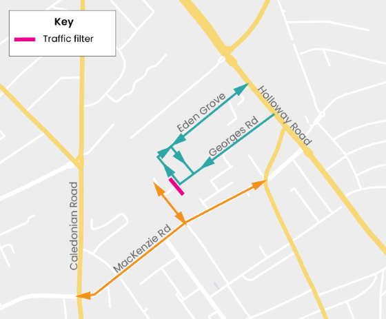
Georges Road.
Type of change
Changes outside the school include:
- making pavements wider
- new planting and trees
- new seating
- more cycle storage
- a trial traffic filter with camera
Location
On Georges Road and at the junction of Georges Road with Eden Grove.
When changes began
The traffic filter started working on 25 September 2023. It is enforced 24 hours a day, 7 days a week.
Blue Badge holders can drive through traffic filters if they live north of Mackenzie Road to Caledonian Road to the west and Holloway Road to the east, and Hornsey Street to the north.
If you are a Blue Badge holder living in the right area but did not get a letter about this, email pfsbluebadge@islington.gov.uk.
Why we have made these changes
In January 2023, we ran a consultation with residents, businesses and the Sacred Heart Primary School community about creating a safer and more pleasant area around the school gate. This included introducing a traffic filter on the junction of Georges Road with Eden Grove.
We collected traffic data in the area in December 2022. There were high levels of cut-through traffic in the area and several vehicle accidents.
After looking at the consultation and traffic data, we decided to install the trial traffic filter School Street.
SEVA Education Kings Cross (used to be Blessed Sacrament Primary School)
Street name
Boadicea Street
Type of closure
A temporary road closure.
Location
The whole of Boadicea Street.
Road closure times
- During term time
- 8:45am to 9:30am
- 3pm to 3:45pm
- Monday to Friday
Why we have made this change
The School Street was installed under an 18-month experimental traffic order. After a public consultation, we made the School Street permanent.
St Andrew's (Barnsbury) CofE Primary School
Street name
Matilda Street.Type of road closure
A temporary road closure.Location
The whole of Matilda Street.Road closure times
- During term time
- 8:30am to 9:15am
- 3:15pm to 4pm
- Monday to Friday
Why we have made this change
The School Street was installed under an 18-month experimental traffic order. We monitored the street to check the impact on the local area. We ran a consultation on the School Street in September 2021.
Monitoring results
- Nitrogen dioxide levels went down by 27% since 2018
- Traffic reduced by 59% during School Street hours
- Average speed stayed the same during School Street hours
Consultation results
- 34 responses from adults
- 47% saw a change in how children and parents travelled to school (53% said "no" or "no change")
- 12% noticed an improvement in the air quality around the school during school street times (3% said it was worse, 85% did not notice a change)
- 29% felt safer around the school during school street times (71% did not feel safer)
- 35% of free text answers to the question “overall, what do you feel about the School Street trial?” were positive
- 27 responses received from children of which 63% were seen as supportive
For the full consultation results for this school, read the School Streets phase 1 consultation report.
St John Evangelist
Address
St John Evangelist
What?
A temporary road closure will be introduced
Where?
Duncan Street, between Islington High Street and Duncan Terrace
When will the temporary road closure operate?
- From 12 November 2018
- 8.15am to 9.15am and 3.00pm to 3.45pm during term-time
- Monday to Friday
Why are these changes being proposed
In July 2018 the Council consulted local residents, businesses and the St John Evangelist RC School community on restricting traffic on Duncan St at school start and finish times, the results of the consultation showed the 83% or responders supported the scheme.
Many of Islington’s schools are located in or near areas of high pollution and children are particularly vulnerable to the effects of air pollution. The School Street Scheme aims to reduce through traffic which will make a safer and more pleasant environment for everyone.
For more information on school streets contact public realm or call Islington Council on 020 7527 2000
St John’s Highbury Vale C of E Primary School
Address
Conewood Street and Legard Road.
What?
A temporary road closure was introduced in September 2020.
Where?
The full length of Conewood Street and Legard Road.
When will the temporary road closure operate?
- 8.30am to 9.15am and 3pm to 4pm during term-time
- Monday to Friday
Why are these changes being proposed?
As part of the council’s people-friendly streets programme we accelerated the council’s School Streets programme and introduced a School Street in your area.
The School Street was installed under an 18-month experimental traffic order with the council closely monitoring the street to assess the impact on the local area. We consulted on the School Street in September 2021 and have now published the results.
Monitoring results
- Nitrogen Dioxide levels decreased by 31% since 2018
- Traffic has reduced by 31% during School Street operational hours
- Speed has decreased by 5% during School Streets operational hours
Consultation results
- 55 responses received from adults
- 67% noticed a change in how children and parents are traveling to school (33% said no or no change)
- 55% noticed an improvement change in the air quality around the school during school street times (2% said it was worse, 44% didn’t notice a change)
- 75% felt safer around the school during school street times (25% didn’t feel safer)
- In response to “overall what do you feel about the School Street trial” - 80% of the free text responses were categorised as positive
- 20 responses received from children of which 95% were seen as supportive
For the full consultation results for this school, please view the full School Streets phase 1 consultation report.
St John’s Upper Holloway CofE Primary School
Address
Pemberton GardensWhat?
A temporary road closure will be introducedWhere?
Pemberton Gardens (between Pemberton Terrace and St John’s Grove)When will the temporary road closure operate?
- From 04 January 2021
- 8.30am to 9.15am and 3.00pm to 4.00pm during term-time
- Monday to Friday
Why are these changes being proposed?
As part of the council’s people-friendly streets programme we accelerated the council’s School Streets programme and introduced a School Street in your area.
The School Street was installed under an 18-month experimental traffic order with the council closely monitoring the street to assess the impact on the local area. We consulted on the School Street in February 2022 and have now published the results.
Monitoring results
- Traffic across the School Street zone fell during the morning school run by 85% and 78% during afternoon pick-up times
- The proportion of vehicles speeding decreased by 1% during School Street hours
- Levels of nitrogen dioxide increased by 14% compared to 2020 and decreased by 18% compared to 2019
- Cycling levels on Pemberton Gardens decreased by 39% during School Street hours
St Jude and St Paul's CofE Primary School (suspended on 21 July 2025)
We suspended the School Streets for Highbury Quadrant and St Jude and St Paul's Primary School on 21 July 2025. This is because of the council’s decision to close the schools.
Vehicles can drive these streets at any time.
The council will decide to continue, change or end the School Streets at some time in the future. We will tell you about how you can share your thoughts and views when we have planned to hold a consultation with you about this School Street.
Street name
Kingsbury Road, Kingsbury Terrace and Burder Close.
Type of road closure
A temporary road closure.
Location
The whole of:
- Kingsbury Road
- Kingsbury Terrace
- Burder Close
Road closure times
- During term time
- 8:30am to 9:15am
- 3pm to 3:45pm
- Monday to Friday
Why we made this change
The School Street was installed under an 18-month experimental traffic order. We monitored the street to check the impact on the local area. We ran a consultation on the School Street in September 2021.
Monitoring results
- Nitrogen dioxide levels went down by 32% since 2018
- Traffic reduced by 8% during School Street hours
- Average speed stayed the same during School Streets hours
Consultation results
- 29 responses from adults
- 41% saw a change in how children and parents travelled to school (59% said "no" or "no change")
- 17% noticed an improvement in the air quality around the school during school street times (10% said it was worse, 72% did not notice a change)
- 34% felt safer around the school during school street times (66% did not feel safer)
- 45% of free text answers to the question “overall, what do you feel about the School Street trial?” were positive
- 20 responses from children, 80% supportive
For the full consultation results for this school, read the School Streets phase 1 consultation report.
St Luke's C of E Primary School
Street name
Radnor Street, Lizard Street, Bartholomew Square, and Mitchell Street
Type of road closure
A temporary road closure.
Location
- Radnor Street
- Lizard Street
- Bartholomew Square
- Mitchell Street
- Ironmonger Row (from Norman Street to Radnor Street)
Road closure times
- During term time
- 8:40am to 9:20am
- 3pm to 3:45pm
- Monday to Friday
Why we have made this change
Many of Islington’s schools are in or near areas of high air pollution. The School Street aims to reduce traffic on these roads which will make a safer and more pleasant environment for everyone.
St Marks primary school
Address
Sussex Way, Whewell Road, Landseer Road and Alexander Road
What?
A temporary road closure will be introduced
Where?
Sussex Way, between Kingsdown Road and Tollington Way, including Whewell Road, Landseer Road and Alexander Road, from Cornwallis Road to Sussex Way
When will the temporary road closure operate?
- From 25 March 2019
- 8.20am to 9.10am and 3.15pm to 4pm during term-time
- Monday to Friday
Why are these changes being proposed
In November 2018 the Council consulted local residents, businesses and the St Marks C of E Primary School community on restricting traffic on sections of Sussex Way, between Kingsdown Road and Tollington Way, including Whewell Road, Landseer Road and Alexander Road, from Cornwallis Road to Sussex Way, at school start and finish times. The results of the consultation showed that 66% of respondents supported the scheme.
Many of Islington’s schools are located in or near areas of high pollution and children are particularly vulnerable to the effects of air pollution. The School Street Scheme aims to reduce through traffic which will make a safer and more pleasant environment for everyone.
For more information on school streets contact public realm or call Islington Council on 020 7527 2000
St Mary Magdalene Primary School
Address
Lough Road and Bride Street.
What?
A temporary road closure was introduced in September 2020.
Where?
Lough Road (between Bride Street and Sheringham Road) and Bride Street (between Liverpool Road and Westbourne Road).
When will the temporary road closure operate?
- 8.00am to 9.00am and 3.15pm to 4.15pm during term-time
- Monday to Friday
Why are these changes being proposed?
As part of the council’s people-friendly streets programme we accelerated the council’s School Streets programme and introduced a School Street in your area.
The School Street was installed under an 18-month experimental traffic order with the council closely monitoring the street to assess the impact on the local area. We consulted on the School Street in September 2021 and have now published the results.
Monitoring results
- Nitrogen Dioxide levels decreased by 26% since 2018
- Traffic has reduced by 66% during School Street operational hours
- Speed has decreased by 13% during School Streets operational hours
Consultation results
- 38 responses received from adults
- 61% noticed a change in how children and parents are traveling to school (39% said no or no change)
- 32% noticed an improvement change in the air quality around the school during school street times (5% said it was worse, 57% didn’t notice a change)
- 61% felt safer around the school during school street times (39% didn’t feel safer)
- In response to “overall what do you feel about the School Street trial” - 59% of the free text responses were categorised as positive
- 30 responses received from children of which 71% were seen as supportive
For the full consultation results for this school, please view the full School Streets phase 1 consultation report.
St Mary’s CofE Primary School
Street name
Fowler Road.
Type of road closure
A temporary road closure.
Location
The whole of Fowler Road.
Road closure times
- During term time
- 8:30am to 9:15am
- 3:15pm to 4pm
- Monday to Friday
Why we made this change
The School Street was installed under an 18-month experimental traffic order. We monitored the street to check the impact on the local area. We ran a consultation on the School Street in September 2021.
Monitoring results
- Nitrogen dioxide levels went down by 32% since 2018
- Traffic reduced by 12% during School Street hours
- Average speed decreased by 7% during School Streets hours
Consultation results
- 20 responses from adults
- 30% saw a change in how children and parents travelled to school (70% said "no" or "no change")
- 20% noticed an improvement in the air quality around the school during school street times (10% said it was worse, 70% did not notice a change)
- 45% felt safer around the school during school street times (55% did not feel safer)
- 58% of free text answers to the question “overall, what do you feel about the School Street trial?” were positive
- 24 responses from children, 88% were supportive
For the full consultation results for this school, read the School Streets phase 1 consultation report.
St Paul's Steiner Primary School
Address
Marquess Road
What?
A temporary road closure will be introduced
Where?
The full length of Marquess Road
When will the temporary road closure operate?
- From 04 January 2021
- 8.00am to 9.00am and 3.00pm to 4.00pm during term-time
- Monday to Friday
Why are these changes being proposed?
As part of the council’s people-friendly streets programme we accelerated the council’s School Streets programme and introduced a School Street in your area.
The School Street was installed under an 18-month experimental traffic order with the council closely monitoring the street to assess the impact on the local area. We consulted on the School Street in February 2022 and have now published the results.
Monitoring results
- Traffic on Marquess Road fell during the morning school run by 91% and 85% during the afternoon pick-up times
- The proportion of vehicles speeding on Marquess Road remained the same, with no speeding recorded during School Street hours
- Levels of nitrogen dioxide increased by 12% compared to 2020 and decreased by 17% compared to 2019
- Cycling levels on Marquess Road increased by 29% during School Street hours
Consultation results
-
39 responses received from adults
-
26% of respondents state that they have changed the way they travel to sustainable transport modes (69% said no)
-
36% agreed that air quality has improved around the school during School Street times (26% disagreed)
-
54% agreed that road danger has reduced during School Street times (36% disagreed)
-
In response to "overall what do you feel about the School Street trial" - 64% of the free text responses were categorised as positive
-
23 responses received from children of which 67% were categorised as positive
For the full consultation results for this school, please view the full School Streets phase 2 consultation report.
St Peter and St Paul Catholic Primary School
Address
Compton Street (from Agdon Street to Goswell Road) and Cyrus Street
What?
A temporary road closure will be introduced
Where?
Compton Street (from Agdon Street to Goswell Road) and Cyrus Street
When will the temporary road closure operate?
- From 3 June 2019
- 8.30am to 9.15am and 2.45pm to 3.45pm during term-time
- Monday to Friday
Why are these changes being proposed
In July 2019 the Council consulted local residents, businesses and the St. Peter & St. Paul Catholic Primary School community on restricting traffic on Compton Street (from Agdon Street to Goswell Road) and Cyrus Street at school start and finish times. The results of the consultation showed that 81% of respondents supported the scheme.
Many of Islington’s schools are located in or near areas of high pollution and children are particularly vulnerable to the effects of air pollution. The School Street Scheme aims to reduce through traffic which will make a safer and more pleasant environment for everyone.
For more information on school streets contact public realm or call Islington Council on 020 7527 2000
Elizabeth Garrett Anderson School and The Gower School
Street name
Donegal Street, Rodney Street, Collier Street and Cynthia Street.
Type of closure
A temporary road closure from September 2026.
Location
- The whole of Donegal Street, from Rodney Street to Penton Street
- The whole of Rodney Street, from Wynford Street to Pentonville Road
- Collier Street, from Cumming Street to Rodney Street
- The whole of Cynthia Street
Road closure times
- During term time
- 8:15am to 9am
- 3pm to 4:30pm
- Monday to Friday
Why we have proposed this change
We installed the School Street under an 18-month experimental traffic order. We are monitoring the street to find out the impact it will have on the local area.
This is a trial for 18 months. When the experimental traffic order begins, there is an "objection period" for 6 months.
How to comment on this change
If you want to make an official objection, saying "no" to this change, you have write to us and explain why you are objecting.
You can send an objection until 2 March 2027.
Send it to us
- by email: environment@islington.gov.uk
- by post: Environment, 1 Cottage Road, London, N7 8TP
We may publish any objection in a public document or on a webpage.
Thornhill Primary School
Street name
Thornhill Road and Lofting Road.
Type of road closure
A temporary road closure.
Location
- Thornhill Road (between Lofting Road and Barnsbury Street)
- Lofting Road (between Thornhill Road and Lambert Street)
- Brayfield Terrace
Road closure times
- During term time
- 8:30am to 9:15am
- 3pm to 3:45pm
- Monday to Friday
Why we have made this change
The School Street was installed under an 18-month experimental traffic order. We monitored the street to check the impact on the local area. We ran a consultation on the School Street in September 2021.
Monitoring results
- Nitrogen dioxide levels went down by 24% since 2018
- Traffic has reduced by 63% during School Street hours
- Speed has decreased by 11% during School Street hours
Consultation results
- 163 responses from adults
- 64% saw a change in how children and parents travelled to school (36% said "no" or "no change")
- 46% noticed an improvement in the air quality around the school during school street times (4% said it was worse, 50% did not notice a change)
- 62% felt safer around the school during school street times (38% did not feel safer)
- 71% of free text answers to “overall, what do you feel about the School Street trial?” were positive
- 41 responses received from children, 83% were supportive
For the full consultation results for this school, read the School Streets phase 1 consultation report.
Tufnell Park Primary School and The Bridge School
Street name
Carleton Road and Dalmeny Road.
Type of road closure
A temporary road closure.
Location
- Carleton road (between Huddleston Road and Dalmeny Avenue)
- Dalmeny Road (between Anson Road and Carleton Road)
- Dalmeny Avenue (from the western arm of the junction with Carleton Road to the eastern arm of the junction with Carleton Road)
Road closure times
- During term time
- 8am to 9am
- 3pm to 4pm
- Monday to Friday
Why we have made this change
The School Street was installed under an 18-month experimental traffic order. We monitored the street to check the impact on the local area. We ran a consultation on the School Street in September 2021.
Monitoring results
- Nitrogen dioxide levels went down by 34% since 2018
- Traffic reduced by 62% during School Street hours
- Speed decreased by 15% during School Streets hours;
Consultation results
- 94 responses from adults
- 25% saw a change in how children and parents travelled to school (75% said "no" or "no change")
- 44% noticed an improvement in the air quality around the school during school street times (1% said it was worse, 55% did not notice a change)
- 73% felt safer around the school during school street times (27% did not feel safer)
- 72% of free text answers to the question “overall what do you feel about the School Street trial?” were positive
- 27 responses from children, 93% were supportive
For the full consultation results for this school, read the School Streets phase 1 consultation report.
Vittoria Primary School (formerly Copenhagen Primary School)
Street name
Treaty Street
Type of closure
A temporary road closure.
Location
The whole of Treaty Street.
Road closure times
- During term time
- 8:15am to 9:00am
- 3pm to 3:45pm
- Monday to Friday
Why we have made this change
The School Street was introduced under an 18-month experimental traffic order. After a public consultation, we made the change permanent.
Many of Islington’s schools are located in or near areas of high pollution. The School Street scheme aims to reduce through traffic which will make a safer and more pleasant environment for everyone.
Whitehall Park Primary School
Address
Ashmount Road, Gresley Road and Dresden Road.
What?
A temporary road closure was introduced in September 2020. This was extended into Dresden Road as a trial in March 2023.
Where?
The full length of Ashmount Road, Gresley Road and Dresden Road.
When will the temporary road closure operate?
- 8.30am to 9.15am and 3.15pm to 4pm during term-time
- Monday to Friday
Why are these changes being proposed?
As part of the council’s people-friendly streets programme we accelerated the council’s School Streets programme and introduced a School Street in your area.
The School Street was installed under an 18-month experimental traffic order with the council closely monitoring the street to assess the impact on the local area. We consulted on the School Street in September 2021 and decided to make the School Street permanent.
For the full consultation results for this school, please view the full School Streets phase 1 consultation report.
School Street extension
The suggestion of extending the existing School Street at Whitehall Park School was first raised in the public consultation on making the School Street permanent in September 2021. The School Street extension into Dresden Road addresses road danger concerns by removing any traffic or additional parking on Dresden Road during the School Street hours when the street is most used by people walking and cycling to school.
To ensure that you can have your say on how the measures are working, we have chosen to implement the extension on a trial basis, under an Experimental Traffic Order (ETO). An Experimental Traffic Order (ETO) is like a permanent Traffic Regulation Order in that it is a legal document that imposes traffic and parking restrictions. However, unlike a Traffic Regulation Order an ETO can only stay in force for a maximum of 18 months while the effects are monitored and assessed. An ETO is made under Sections 9 and 10 of the Road Traffic Regulation Act 1984.
Once an ETO comes into force there is a six month period in which objections can be made. If the ETO is subsequently modified, objections can be made in the six months following from the date of the changes. You can read more about how to make a formal objection on our Frequently Asked Questions page, under the question 'What is an Experimental Traffic Order (ETO)?'
William Tyndale Primary School
Address
Sable Street
What?
A temporary road closure will be introduced
Where?
The full length of Sable Street
When will the temporary road closure operate?
- From 04 January 2021
- 8.00am to 9.00am and 3.00pm to 4.00pm during term-time
- Monday to Friday
Why are these changes being proposed?
As part of the council’s people-friendly streets programme we accelerated the council’s School Streets programme and introduced a School Street in your area.
The School Street was installed under an 18-month experimental traffic order with the council closely monitoring the street to assess the impact on the local area. We consulted on the School Street in February 2022 and have now published the results.
Monitoring results
- Traffic on Sable Street fell during the morning school run by 55% and 72% during the afternoon pick-up time
- The proportion of vehicles speeding on Sable Street remained the same, with no speeding recorded during School Street hours
- Levels of nitrogen dioxide increased by 5% compared to 2020 and decreased by 16% compared to 2019
- Cycling levels on Sable Street increased by 93% during School Street hours
Consultation results
- 37 responses received from adults
- 22% of respondents state that they have changed the way they travel to sustainable transport modes (73% said no)
- 57% agreed that air quality has improved around the school during School Street times (22% disagreed)
- 68% agreed that road danger has reduced during School Street times (24% disagreed)
- In response to "overall what do you feel about the School Street trial" - 68% of the free text responses were categorised as positive
- 25 responses received from children of which 52% were categorised as positive
For the full consultation results for this school, please view the full School Streets phase 2 consultation report.
Winton primary school
Address
Killick Street and Collier Street
What?
A temporary road closure will be introduced
Where?
Killick Street and Collier Street
When will the temporary road closure operate?
- From 3 June 2019
- 8.30am to 9.15am and 3.15pm to 4pm during term-time
- Monday to Friday
Why are these changes being proposed
In February 2019 the Council consulted local residents, businesses and the Winton Primary School community on restricting traffic on Killick Street and Collier Street and no left turn into Southern Street at school start and finish times. The results of the consultation showed that 84% of respondents supported the scheme.
Many of Islington’s schools are located in or near areas of high pollution and children are particularly vulnerable to the effects of air pollution. The School Street Scheme aims to reduce through traffic which will make a safer and more pleasant environment for everyone.
For more information on school streets contact public realm or call Islington Council on 020 7527 2000
Yerbury primary school
Street name
Tytherton Road, Yerbury Road and Foxham Road
Type of closure
A temporary road closure.
Location
- Foxham Road (between Beversbrook Road and Yerbury Road)
- Tytherton Road (between Beversbrook Road and Yerbury Road)
- Yerbury Road (between Tytherton Road and Foxham Road)
Road closure times
- During term time
- 8:45am to 9:30am
- 3:15pm to 4pm
- Monday to Friday
Why we made this change
In November 2018, we ran a consultation for residents, businesses and the Yerbury Primary School community about restricting traffic on sections of Tytherton Road, Yerbury Road and Foxham Road, at school start and finish times. The results of the consultation showed that 79% supported the scheme.
Many of Islington’s schools are located in or near areas of high air pollution. The School Street aims to reduce traffic on these roads which will make a safer and more pleasant environment for everyone.
Useful documents
-
Robert Blair School Street consultation leaflet

(pdf, 4 MB)
-
St Joseph's School Street consultation leaflet
(pdf, 4 MB)
-
School Streets Phase 2 consultation report
(pdf, 6 MB)
-
Ambler and Canonbury Consultation Report
(pdf, 2 MB)
-
School Streets Phase 1 consultation report
(pdf, 12 MB)
-
Hargrave Park School Streets changes - resident leaflet
(pdf, 302 KB)
-
Thornhill School Streets changes - resident leaflet
(pdf, 620 KB)
-
St Andrew's School Streets changes - resident leaflet
(pdf, 605 KB)
-
St Luke's School Street leaflet
(pdf, 791 KB)
-
1. Whitehall Park School Letter
(pdf, 263 KB)
-
14. Tufnell Park Primary School
(pdf, 228 KB)
-
2. St John's Highbury Vale School Letter
(pdf, 539 KB)
-
Laycock Primary School
(pdf, 267 KB)
-
5. Thornhill Primary School Letter
(pdf, 520 KB)
-
15. St Andrew's (Barnsbury) CofE Primary School
(pdf, 222 KB)
-
12. St Mary Magdalene Academy
(pdf, 588 KB)
-
William Tyndale - Resident Notification
(pdf, 167 KB)
-
William Tyndale -School Street Plan
(pdf, 740 KB)