In September 2020, as part of our people-friendly streets programme, we introduced a low traffic neighbourhood trial in Clerkenwell Green.
Like many neighbourhoods within the borough, Clerkenwell Green has suffered from increased traffic volumes in recent years from the use of the area as a short cut.
The trial aimed to:
- make it easier and safer to walk and cycle
- clean up the air we breathe
- reduce road danger.
We introduced the following traffic filters:
- Clerkenwell Green where it connects to Aylesbury Street
- both ends of Sans Walk
- both ends of Corporation Row. The two filters in Corporation Row are enforced by cameras.
You can see locations of the traffic filters on Google maps or view the map of the Clerkenwell Green low traffic neighbourhood (LTN).
Next steps for Clerkenwell Green
The positive outcomes from the consultation and monitoring reports support our decision to make exemptions for Blue Badge holders living in the Clerkenwell Green low traffic neighbourhood from camera enforced traffic filters permanent. The documents about the decisions on these changes are in the ‘useful documents’ section.
You can find out more information on the exemption and read our Blue Badge holder frequently asked questions.
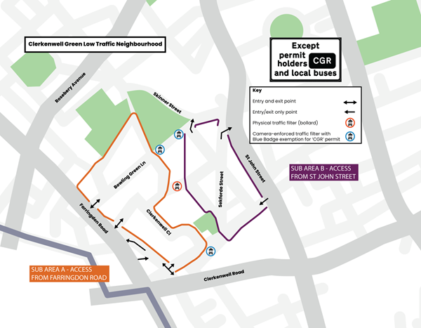
- After 6 February 2023, you cannot get to Clerkenwell Green from Clerkenwell Road. You can see the map of access to the area.
- We will keep the existing sign that says 'unsuitable for long vehicles' at the south-westbound section of Skinner Street next to numbers 45 to 49 that leads to Corporation Row.
We are improving the surroundings in Clerkenwell Green. We consulted on these proposals in 2017, receiving support from 82 per cent of 433 respondents and will continue to build on the benefits of the Clerkenwell Green low traffic neighbourhood. You can find out more about the proposals on the Clerkenwell Green webpage.
Monitoring
We published our most recent monitoring report for the Clerkenwell Green people-friendly streets neighbourhood in January 2023. The report includes data collected in August 2020 and September 2021. It also has data collected in October 2022 to monitor the scheme after we exempted eligible Blue Badge holders.
We published our pre-consultation monitoring report for the Clerkenwell Green PFS trial area in November 2021. This report includes data one year on from the launch of the people-friendly streets trial in September 2020.
We published the interim monitoring report for the Clerkenwell Green PFS trial area in May 2021.
Consultation
We held a public consultation on the Clerkenwell Green people-friendly streets neighbourhood between 4 November and 2 December 2021.
We have now published our pre-consultation engagement results report for Clerkenwell Green. This report includes all feedback up until the public consultation (4 November 2021 – 2 December 2021) from Commonplace and Trial feedback surveys, email correspondence, formal objections and stakeholder meetings.
We have also published our independently written consultation report for Clerkenwell Green. This report includes feedback received through the public consultation (4 November – 2 December 2021).
Map of the Clerkenwell Green low traffic neighbourhood
Traffic filters are at the following locations: Clerkenwell Green where it connects to Aylesbury Street, both ends of Sans Walk, and both ends of Corporation Row. The two filters in Corporation Row are enforced by cameras and the first phase proposals for the public realm scheme changed the bollard-enforced filter on Clerkenwell Green close to Aylesbury Street into a camera-enforced filter. The map below shows vehicle access routes for Clerkenwell Green from 6 February 2023.


